Hi Everyone....Our Blog Is Back!
And just in time for Valentine's Day Weekend.

Our apologizes for not getting back to blogging earlier this morning. After a much needed R&R weekend, the husband and I celebrated 6 years of married bliss (and 11 years of being together) on Super Bowl Sunday. And to think...RRMT, Inc. was the site where my hubby proposed several years back on a camping trip...smart man! For me, he couldn't have picked a better place that I hold more dear! Apparently he knew the way to my heart. Enough about the sappy stuff...moving on now! After getting caught up on emails and other stuff while away, be rest assured the blog is back and just in time to keep you updated on this crazy Texas weather....1, 2, 3...Get ready!
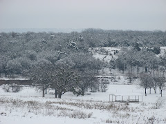
NO rain this weekend, but last (Sunday) night, we received 3 quarters of an inch of rain. For a while this morning, there was a fine mist falling, but nothing measurable to report, just to make for a messy, dreary, cold day. This afternoon as of 3:50 p.m., we have a current temperature of 39 degrees. It is cloudy and overcast today as the wind is really bad, making it feel even colder than it really is. Hang on to your seat because the weather from today just goes downhill from here...while we do not have any rain falling at the current moment, the forecast is calling for light (non-accumulating) snow late this evening/tonight and accumulating snow for Thursday. And the temperatures this week are going to feel like we are in the Arctic...low 40's to low/mid 30's for highs as we go thru the week. We'll keep everyone posted.
But for now, there is a special statement for our area as issued by the National Weather Service...for more details, see below:
Issued by The National Weather Service
Dallas/Fort Worth, TX
3:30 pm CST, Mon., Feb. 8, 2010
... COLD TONIGHT THEN WINTRY WEATHER EXPECTED ACROSS MUCH OF NORTH TEXAS EARLY THURSDAY INTO THURSDAY NIGHT...
A STRONG COLD FRONT WILL MOVE THROUGH NORTH TEXAS TONIGHT WITH NORTH WINDS INCREASING TO 15 TO 25 MPH. ALL OF THE PRECIPITATION WILL HAVE MOVED EAST OF THE AREA BY THE TIME TEMPERATURES FALL TO BELOW FREEZING DURING THE OVERNIGHT HOURS. LOW TEMPERATURES WILL FALL TO BETWEEN 24 AND 29 DEGREES ACROSS MOST OF NORTH TEXAS... SO ANY RESIDUAL WATER ON AREA ROADS WILL LIKELY FREEZE. PATCHY ICE IS LIKELY TO FORM DURING THE OVERNIGHT AND EARLY MORNING HOURS... MAKING ROADS SLICK. WIND CHILLS WILL BE IN THE LOW TEENS EARLY TUESDAY MORNING.
ANOTHER STORM SYSTEM WILL APPROACH THE AREA BY MIDWEEK WHILE TEMPERATURES REMAIN COLD ACROSS THE REGION. IT APPEARS AT THIS TIME THAT SUFFICIENT MOISTURE WILL MOVE NORTHWARD IN ADVANCE OF THIS SYSTEM FOR SNOWFALL TO OCCUR ACROSS MUCH OF NORTH TEXAS DURING THE DAY THURSDAY INTO THURSDAY EVENING. WHILE THERE IS STILL SOME UNCERTAINTY AS TO THE SPEED AND TRACK OF THE EVOLVING SYSTEM... WHICH COULD SIGNIFICANTLY AFFECT THE THERMAL PROFILE FAVORABLE FOR SNOW PRODUCTION... OVERALL CONFIDENCE IN THIS STORM SYSTEM IS INCREASING.
AREAS NORTH OF A KILLEEN TO WACO TO ATHENS LINE APPEAR TO HAVE THE BEST CHANCE FOR ACCUMULATING SNOWS DURING THE DAY THURSDAY. TEMPERATURES AT THE SURFACE WILL BE AT OR SLIGHTLY ABOVE FREEZING AT THE ONSET OF THE EVENT... WHICH MEANS THAT SNOW WILL LIKELY MELT INITIALLY... THEN ACCUMULATE AS HEAVIER BANDS DEVELOP. AT THIS TIME IT APPEARS THAT ACCUMULATIONS OF 1 TO 3 INCHES WILL BE POSSIBLE. UNCERTAINTY IN THE EXACT TRACK AND SPEED OF THIS SYSTEM COULD SIGNIFICANTLY AFFECT SNOWFALL ACCUMULATION TOTALS.
---So folks, by the end of the week, you might be snowmobiling again much like you could have done at Christmas. No, joking aside, it doesn't appear we will get as much as we did over the holidays, but it does look as though the approaching winter weather storm system that will arrive by end of the week may possibility be enough to make for some beautiful winter snow trail riding, but we still have to wait and see. This may be the perfect Valentine's Day Weekend Receipe...
Valentine's Day Weekend + The Possibility of Snow =
Romantic Bulcher, Texas Getaway!
Have a great rest of the day...and week!
WEEKEND RV RENTALS
Do you have your RV Rental for this weekend? RRMT, Inc. offers Member RV Site Rentals on a daily basis. Reservations are recommended if you desire a particular RV Site. Otherwise, all walk-up RV Site rentals are welcome as well. Please note that in addition to these rental sites, as usual, RRMT, Inc. also offers free other campsites that are always available via first come-first serve for your convenience.
2010 RRMT, Inc. Memberships Now On Sale!
If you weren't a member in 2009, but are planning on joining for 2010...don't forget that 2010 RRMT, Inc. Memberships are now on sale to the general public! Member benefits start immediately. A great deal & just in time for the new year! If you will be visiting the park this weekend, a new 2010 membership may be just what you need! Ask us for details.
2009 RRMT, Inc. Members May Renew Now For 2010!
Registration is now open for current 2009 members to renew their memberships for 2010. You can mail your stuff in or bring it with you to the park office on your next visit. If you will be visiting this weekend, upon check-in at the park office, we can provide you with renewal paperwork to complete if you need any help with finalizing needed park documentation.
RRMT, Inc. will be OPEN this weekend...Valentine's Day Weekend...Saturday, February 13 & Sunday, February 14! We will have park operation hours of 8 a.m. to 6 p.m. both days. All Members, Guests, and Visitors Welcome This Weekend!
NO BURN BAN for Cooke County or thus at RRMT, Inc.
Happy Monday...
RRMT, Inc. Staff