TRAIL/WEATHER CONDITIONS
Half Way Thru The Week On This Wednesday...
NO rain yesterday or overnight. This morning as of 9:55 a.m., we have a current temperature of 52 degrees. It is cloudy and overcast this morning as we only anticipate highs today to be in the upper 50's. Enjoy because it is all downhill from today as far as weather goes...tomorrow (Thursday) the forecast is calling for rain & thunderstorms and on Friday a.m., a light wintry mix is expected. But we'll just have to wait and see. We have received NO rain thus far today. There is a special weather alert for our area as issued by the National Weather Service preparing people for the possible bad weather conditions toward the end of the week. See below for more details:
Issued by The National Weather Service
Dallas/Fort Worth, TX
4:35 am CST, Wed., Jan. 27, 2010
... A STRONG WINTER STORM SYSTEM WILL AFFECT NORTH TEXAS THURSDAY THROUGH FRIDAY...
A POWERFUL UPPER LEVEL STORM SYSTEM WILL MOVE THROUGH THE SOUTHERN PLAINS AND BRING A PERIOD OF UNSETTLED WEATHER AND COLDER TEMPERATURES TO NORTH TEXAS. MOISTURE AND LIFT AHEAD OF THE UPPER LEVEL SYSTEM WILL RESULT IN WIDESPREAD RAIN AND A FEW THUNDERSTORMS THURSDAY AND INTO THURSDAY NIGHT. RAINFALL AMOUNTS WILL AVERAGE 1 TO 2 INCHES... WITH TOTALS UP TO 3 INCHES POSSIBLE NORTH OF THE I-20 CORRIDOR.
MEANWHILE A STRONG COLD FRONT WILL MOVE SOUTH ACROSS NORTH TEXAS THURSDAY AND THURSDAY NIGHT. AS TEMPERATURES COOL BEHIND THE FRONT... THE RAIN SHOULD CHANGE OVER TO A LIGHT WINTRY MIX OF PRECIPITATION TO THE NORTHWEST OF A LINE FROM LAMPASAS... TO WACO... TO TERRELL... TO SULPHUR SPRINGS BY FRIDAY MORNING. ICE ACCUMULATIONS OF UP TO A QUARTER INCH ARE POSSIBLE ALONG AND NORTHWEST OF A MINERAL WELLS TO GAINESVILLE LINE. A WINTER STORM WATCH HAS BEEN ISSUED FOR THESE AREAS AS A RESULT.
SOME MINOR ACCUMULATIONS OF ICE OCCURRING FROM LIGHT FREEZING DRIZZLE WILL BE POSSIBLE ACROSS THE REMAINDER OF NORTH TEXAS FRIDAY MORNING.
THE MOST SIGNIFICANT WINTER PRECIPITATION IS EXPECTED TO REMAIN OVER THE TEXAS PANHANDLE AND OKLAHOMA WHERE THE CENTER OF UPPER LEVEL STORM SYSTEM IS FORECAST TO TRACK. HOWEVER... DUE TO UNCERTAINTIES ON THE EXACT TRACK OF THE SYSTEM... RESIDENTS ACROSS NORTH TEXAS ARE ENCOURAGED TO MONITOR THE LATEST FORECASTS FOR ANY CHANGES DURING THE NEXT COUPLE OF DAYS.
WEEKEND RV RENTALS
Do you have your RV Rental for this weekend? RRMT, Inc. offers Member RV Site Rentals on a daily basis. Reservations are recommended if you desire a particular RV Site. Otherwise, all walk-up RV Site rentals are welcome as well. Please note that in addition to these rental sites, as usual, RRMT, Inc. also offers free other campsites that are always available via first come-first serve for your convenience.
2010 RRMT, Inc. Memberships Now On Sale!
If you weren't a member in 2009, but are planning on joining for 2010...don't forget that 2010 RRMT, Inc. Memberships are now on sale to the general public! Member benefits start immediately. A great deal & just in time for the new year! If you will be visiting the park this weekend, a new 2010 membership may be just what you need! Ask us for details.
2009 RRMT, Inc. Members May Renew Now For 2010!
Registration is now open for current 2009 members to renew their memberships for 2010. You can mail your stuff in or bring it with you to the park office on your next visit. If you will be visiting this weekend, upon check-in at the park office, we can provide you with renewal paperwork to complete if you need any help with finalizing needed park documentation.
NO BURN BAN for Cooke County or thus at RRMT, Inc.
RRMT, Inc. will be OPEN this weekend...Saturday, January 30 & Sunday, January 31! We will have park operation hours of 8 a.m. to 6 p.m. both days. All Members, Guests, and Visitors Welcome This Weekend!
Bye,
RRMT, Inc. Staff
RRMT, Inc. is a privately owned & operated 2,700 acre off-road recreational park. We are open all weekends unless otherwise denoted on our events calendar on our website.
RRMT, Inc. Park Brochures Available At Our Park Office!
RRMT, Inc. Park Brochures Available At Our Park Office!

Welcome to RRMT, Inc.'s Blog!
Thanks for visiting our blog. We hope you find it your source for all things "Red River." Our goal with this blog is to bring you up-to-date weather, trail, & park news on a regular basis.
Our passion is preserving this beloved riding area we call Bulcher, Texas...glad you came along for the journey!
Cheers,
RRMT, Inc. Staff
Proud TCU ALUM - Go Frogs!
Our passion is preserving this beloved riding area we call Bulcher, Texas...glad you came along for the journey!
Cheers,
RRMT, Inc. Staff
Proud TCU ALUM - Go Frogs!

RRMT, Inc. Ranked #1 Best Off-Road Destination by RIDE TEXAS Magazine
Support Texas off-road parks & riding areas! Ride Texas!
Support Texas off-road parks & riding areas! Ride Texas!

2010 Memberships On Sale Now!
Current 2009 members may renew their memberships for 2010 at anytime. Also, 2010 RRMT, Inc. Memberships are on sale to the general public! Membership benefits start immediately.


Park Entrance - Feb. 11

View From Pump Jack Hill - Feb. 11
Picture Perfect Bulcher - Feb. 11

Mountain Creek - Christmas Day

View From Pump Jack Hill - Christmas Day

Snow Covered Red Bull Barn - Christmas Day

Winter Wonderland - Christmas Day

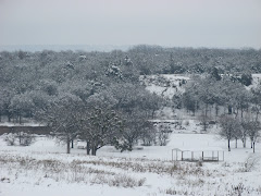
Snow Covered Bulcher, Texas

The Best Trails in Texas!

Rock Bluff

Red Bull Barn

Mountain Creek
Are You A RRMT, Inc. Member?
Did you know that not only does RRMT, Inc. Park Membership entitle you to a lot of great benefits, but it also saves members money?
Our membership program is an affordable option for those that love riding Bulcher, Texas.
The 2010 riding season is upon us, and thus, information has now been released on our website regarding renewing and/or joining for the 2010 riding season.
iRide Bulcher, Texas...
Where do you ride?
Our membership program is an affordable option for those that love riding Bulcher, Texas.
The 2010 riding season is upon us, and thus, information has now been released on our website regarding renewing and/or joining for the 2010 riding season.
iRide Bulcher, Texas...
Where do you ride?
Blog Archive
-
▼
2010
(149)
-
▼
January
(34)
- TRAIL/WEATHER CONDITIONSWonderful Sunday Morning.....
- Saturday Snow PicturesAs promised here are some pi...
- TRAIL/WEATHER CONDITIONSThinking of a Weekend Snow...
- DELAYED OPENING TIME - SATURDAY, JANUARY 30We have...
- TRAIL/WEATHER CONDITIONSSnowy Friday...NO addition...
- TRAIL/WEATHER CONDITIONSGood Thursday Evening...NO...
- ANNOUNCEMENTWe wanted to let everyone know that be...
- TRAIL/WEATHER CONDITIONSHalf Way Thru The Week On ...
- TRAIL/WEATHER CONDITIONSSunny & Bright Tuesday...N...
- TRAIL/WEATHER CONDITIONSThe Start of Another Week....
- TRAIL/WEATHER CONDITIONSFinally the sunshine arriv...
- TRAIL/WEATHER CONDITIONSHowdy...Well first my apol...
- TRAIL/WEATHER CONDITIONSGood Day Mate...Hello Week...
- TRAIL/WEATHER CONDITIONSTerrific Thursday...NO rai...
- TRAIL/WEATHER CONDITIONSHalf Way Thru The Week On ...
- TRAIL/WEATHER CONDITIONSGood Tuesday Afternoon...N...
- TRAIL/WEATHER CONDITIONSAnother Monday...NO rain y...
- TRAIL/WEATHER CONDITIONSHowdy...Yesterday and over...
- TRAIL/WEATHER CONDITIONSHappy Saturday...More mois...
- TRAIL/WEATHER CONDITIONSA Sigh of Relief Goes The ...
- TRAIL/WEATHER CONDITIONSOkay, Where Did Our Sunny ...
- TRAIL/WEATHER CONDITIONSHalf Way Thru The Week On ...
- TRAIL/WEATHER CONDITIONSHello Gorgeous Weather...N...
- TRAIL/WEATHER CONDITIONSReturn To The Work Week On...
- TRAIL/WEATHER CONDITIONSGood Sunday Morning...Well...
- TRAIL/WEATHER CONDITIONSHappy Friday...On This Bit...
- TRAIL/WEATHER CONDITIONSGood Evening...Sorry for o...
- TRAIL/WEATHER CONDITIONSHalf Way Thru The Week On ...
- TRAIL/WEATHER CONDITIONSGood Tuesday Morning Folks...
- TRAIL/WEATHER CONDITIONSHappy January...Well folks...
- TRAIL/WEATHER CONDITIONSHappy Sunday Morning!NO pr...
- TRAIL/WEATHER CONDITIONSNeed A New Year's Resoluti...
- TRAIL/WEATHER CONDITIONSHappy New Year...2010A New...
- Make Your New Year Merry & Bright...Book A Member ...
-
▼
January
(34)
START YOUR ADVENTURE TODAY...RIDE BULCHER, TEXAS!